


Return to Crianlarich
- Jan 15, 2018
- 7 min read

Ben More and Stob Binnein from Cruach Ardrain
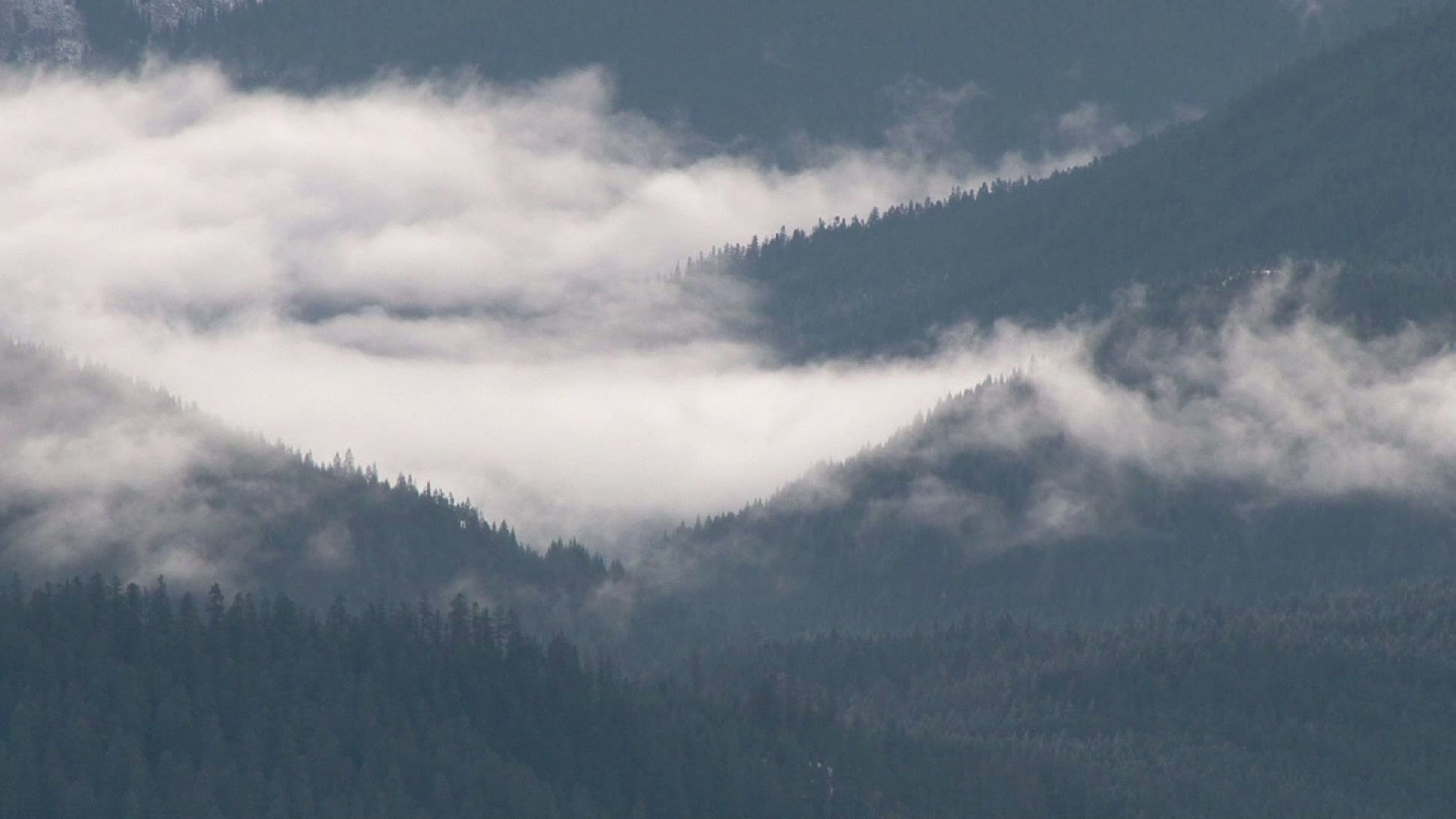
I had joined my wife and some friends for a few days on the West Highland Way and as we stopped on the trail between Crianlarich and Tyndrum I was captivated by the view that had opened up behind us.
Cruach Adrain rose proudly from its skirts of conifers, a lovely peak with its ‘Y’-shaped gully imprinted on its face but that morning it was its higher neighbours that dominated the view – Ben More and Stob Binnein, the Castor and Pollux of the Scottish Highlands, and two hills of my youth.
As Glasgwegian teenagers our mountaineering vision rarely went further than these Crianlarich hills. At that time even Glen Coe seemed on the very edge of the known world, so for a few years the Crianlarich and Tyndrum hills were very much the periphery of our hill explorations. I’m not sure if it was a touch of nostalgia or just one of those memorable bouts of insight that the hills are so capable of offering, but I had a sudden longing to renew acquaintance with them.
Despite the fact that Ben More and Stobinian are generally recognised as an item – the two are inextricably joined at the hip by the wonderfully-named Bealach-eader-dha-Beinn – I had only once before climbed them both together.
They’re big mountains, 1174 metres and 1165 metres respectively, indeed they’re the highest peaks in Scotland south of the Tay and while Ben More is a rather big and bulky mountain, rising to a blunt pyramid, Stob Binnein is considerably more shapely, its southern slopes rising rather delicately from a long, sweeping ridge to a truncated, tabled summit.
While Stob Binnein portrays elegance itself, Ben More is different. It’s brutish, a big, brash mountain whose northern slopes sweep down virtually in one fell swoop from its summit all the way to Glen Dochart. Any ascent is relentless, a long pull on tough terrain from glen to summit.
This is a walk that will test your fitness so following a few weeks of gentler walks I decided to assess my own fitness levels, and there are few better places to do that than Ben More’s north-west shoulder. Uncompromising steep slopes rise for over 1000 metres from Glen Dochart to the craggy summit and on a sunny, Sunday morning it was just a question of getting the head down and going for it.
I was rather pleased to reach the summit in well less than two hours, despite some very slippery conditions on the upper parts of the hill where you have to climb through some rocky outcrops. From there easier slopes lead to the summit cairn and trig point. Late in the season hoar frost covered everything, and the ground was frozen as hard as concrete. I almost wished I had an ice axe with me, even though there wasn’t a drop of snow in sight.
With the hard work over I could now look forward to the rest of the day. A beautifully uniform slope drops south to the level Bealach-eadar-dha-Beinn (the disappointingly prosaic name means ‘the pass between the mountains’) from where Stob Binnein’s north ridges rises steeply to its table-top summit.
Other than some cloudy conditions on both summits, the views were exceptional – south, towards the other Glen Falloch hills and the lower, brackish hills of the Trossachs, and north, to a massive jumble of high hills, the mountains of Mamlorn leading the eye all the way to the huge hump-back of Ben Nevis itself.
While the normal route of ascent follows Ben More’s north-west ridge virtually all the way from Benmore Farm to the summit another route follows the Benmore Burn south into the Benmore Glen.
The main advantage of this route is that it avoids the long and tedious climb up the north-west ridge and adds a little variety, the main disadvantage is that the headwaters of the Benmore Burn takes you into very wet and boggy terrain, but not for long.
The spur of Creagan Liatha falls down from Stob Binnein directly to the high point of the Benmore Glen and provides an opportunity to get off the soggy ground and gain some height, and drier ground, before gaining the SSE ridge of Stob Binnein, which then climbs steadily to the summit cairn. It’s a much more challenging route, especially in winter, but does avoid the wet and boggy slopes west of the Bealach-eadar-dha-Beinn.
Encouraged by such a good day I decided to hang fire overnight in my campervan and tackle another of these Breadalbane hills the next day. Rising from a magnificently wooded lower glen to an increasingly wilder landscape that’s characterised by wind blown Scots pines, Glen Falloch forms the north-east boundary of a marvellous mountain range that’s dominated by no less than seven Munros and fourteen tops, the highest group of hills in Britain south of Tayside, so I had plenty of peaks to choose from.

The Crianlarich hills from Ben Challum
I think these hills are seen to best advantage from Tyndrum. Choose a late afternoon in winter and watch Cruach Ardrain reflecting the setting sun from the snow filled Y-Gully of its northern corrie. Its ridges and double summits form an attractive mountain shape that rises from skirts of sitka spruce to stand proudly alongside the indomitable due of Ben More and Stob Binnein.
These Crialarich hills can be broken into several day expeditions, although it is possible to climb Ben More and Stob Binnein in one day and the rest of the Munros – Beinn Chabhair, An Caisteal, Beinn a’ Chroin, Beinn Tulaichean and Cruach Ardrain – in another. That second expedition, with 13 miles or so of rough walking and over 7000ft of ascent, isa long and tough one, and I’d recommend climbing Cruach Ardrain, 3432ft and Beinn Tulaichean, 3104ft together, leaving the rest for another day, and that’s exactly what I did.
The ascent of Cruach Ardrain, 3432ft and its southern neighbour, Beinn Tulaichean, 3104ft makes a great day out at any time of the year but is particularly good if you get snowy winter conditions, especially if you get the conditions I enjoyed while making a Wild Walk for the BBC’s Adventure Show two or three years ago – blue skies, sunshine and snow covered tops were the order of the day and the ascent of the two hills was a wintry delight.
Incidentally, these two Munros can be climbed from the south, from Inverlochlarig Farm where Rob Roy Macgregor spent his last years, dying there on 27th December 1734. Other than paying your last respects to the Macgregor, there isn't really a lot to recommend an ascent from this side. From the farm long grassy slopes are climbed in a north-west direction to reach the ridge just south of the Beinn Tulaichean’s summit. From here it's a straightforward walk along a broad ridge to Cruach Ardrain.
The ascent of the hills from Glen Falloch starts just south of Crianlarich in a car park opposite Keilator farm. I parked the camper in a laybye and crossed a rather boggy field to where a land rover track runs under the railway and climbs up the length of Coire Earb beside the infant River Falloch.
Years ago I used to access these hills from a path that ran through the forest, climbing up to the tree-line on the slopes of Grey Height, a northern outlier of Cruach Ardrain. The Coire Earb route gives a rather more relaxing start to your day, by following the land rover track for about a mile until you’re opposite the corner of the forestry plantation. Just below you a footbridge crosses the river and easy slopes lead to the crumpled summit of Grey Height.
An early Scottish Mountaineering Club journal records an expedition to Cruach Ardrain arranged by Sir Hugh Munro himself and serves as a warning to those who think the ascent of these two Munros lacks challenge. With three companions he left the Crianlarich road at 11.15 am and suggests the climb to Grey Heights was “uninteresting”, but things were about to change.
Munro’s notes say that as the morning drew on the clouds began to drop and soon the group were walking in clouds, “which were neither very wetting or cold.” Calculating that a rough southerly course would take them to the summit, “the very simplicity made us careless and no-one took the trouble to lead.” After half an hour the men disovered their own footprints in the snow. They had walked in a circle.
They decided to continue on their southerly course “wherever it might lead us” and soon found themselves climbing a steeper slope. Indeed they were in a snow gully which required some step-cutting and which, “if it had been longer, the rope might have been serviceable.” Munro records that it was not unlike the north-east face of Ben Laoigh, though not quite as steep, not nearly as long.”
Apparently they had eased their way onto the ENE face of Cruach Ardrain, the Creagan Dubha face, and within minutes reached the summit cairn. How they managed to get across to that side of the peak I have no idea but I am well aware from my own experiences that when the cloud is down and you are not carefully navigating you can end up virtually anywhere. And remember, these mountaineering pioneers didn’t have the benefit of modern maps, accurate compasses and GPS.
From the high point known as Grey Heights, a path climbs over the bumps and knolls of the ridge that leads to Meall Dhamh where, following a short descent, the slopes of Cruach Ardrain begin to steepen appreciably towards its north-west summit, a subsidiary top that’s adorned with two small cairns. The true summit lies just across a shallow col.

Beinn Tulaichean
Beinn Tulaichean is easily reached from here. I passed the twin cairns and dropped down in a southerly direction to a grassy ridge from where it was an easy amble to the 946 metre summit of the second hill, a Munro that is in all honesty more like another subsidiary top of Cruach Ardrain than a separate mountain!
For a slightly different descent route I was tempted by what looked like an easier line. I left the Tulaichean/Cruach Ardrain ridge slightly early to skirt the southern slopes of Cruach Ardrain towards the bealach between the Munro and another of its outliers, Stob Glas. From the bealach the long and gentle slopes of upper Coire Earb drop down to the river where, after a short distance, I picked up the land rover track that carried me all the way back to my starting point, well aware that the hills of my youth are a little more taxing these days, but still pretty wonderful.


Comments